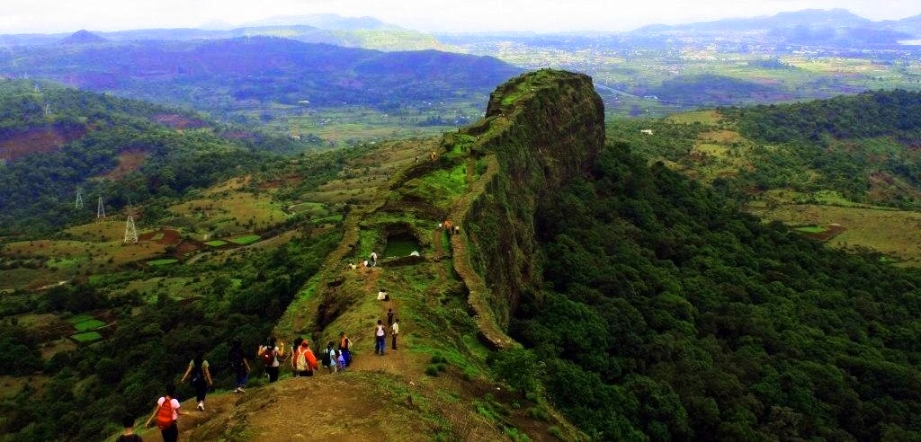
Lohagad Fort In Pune,Maharashtra,India
Lohagad Fort is one of the many hill forts of Maharashtra state in India. Situated close to the hill station Lonavala and 52 km northwest of Pune, Lohagad rises to an elevation of 1,033 m above sea level.Lohagad fort is a formidable fort near Pune. Lohagad makes an ideal trekking destination for trekkers from Pune and Mumbai because of its accesibility, ease of the trek and lush green surroundings. Lohagad at 3400 ft is a wide spread fort. There are 4 doors to Lohagad from the nearby village Lohagadwadi. Lohagad divides the basins of the Indrayani and Pavna.
Trek to lohagad :
Malawli is the nearest railway station from Lohagad and ‘Bhaje Gaav’ is the base village from where you can start the trek to Lohagad. Lohagadwadi is the village from where the steps up the Lohagad fort starts. Distance between Malawli and Lohagadwadi can be covered in around 2-2.5 hrs.
The highlight of Lohagad fort trek is the ‘Vinchu kata’ – fortification resembling a scorpion’s tail. This structure juts out from the main section of the fort and requires an additional 15-20 mins of walking to reach the edge. The durgah is another major landmark within Lohagad which is located near the entrance to the fort – ‘Mahadarwaja’. Laxmi Kothi is a large shelter near the durgah. Lohagad is one of the most visited forts in Maharashtra. Lohagad trek is very popular especially during monsoons.
Nearby places Lohagad:
Karla Caves – Caves near Lohagad.
The Karla Caves is a complex of ancient Buddhist rock-cut shrines in Karla near Lohagad, believed to be built between the 2nd century BC to the 2nd century AD and from the 5th century AD to the 10th century AD. The oldest of the cave shrines to date back to 160 BC.
Map of Lohagad
Compiled by: Townpune.com Team